Bienvenue dans notre guide sur le Garmin Quickdraw Contours ! Vous découvrirez ici une fonctionnalité révolutionnaire qui vous permettra de créer instantanément des cartes Bathymétrique HD personnalisées. Plus besoin de saisir des informations manuellement, le logiciel gratuit Quickdraw Contours de votre traceur sondeur Garmin crée automatiquement vos cartes pendant que vous naviguez.
Que vous soyez un passionné de pêche ou un marin en quête d’aventures, cette innovation vous permettra d’explorer les fonds marins avec une précision inégalée et d’améliorer vos cartes maritimes en ajoutant des détails clairement indiqués à l’écran.
Lisez notre guide et devenez un champion de la bathymétrique avec Garmin Quickdraw Contours et créez et partagez vos propres cartes pour une expérience de navigation et de pêche inoubliable !
Le Garmin QuickDraw Contours est une fonctionnalité innovante et puissante intégrée aux sondeurs Garmin comme ceux de la gamme Striker Vivid. Elle permet aux plaisanciers et aux pêcheurs de créer leurs propres cartes bathymétriques détaillées en temps réel, directement sur l’écran de leur sondeur.
Lorsque le Garmin QuickDraw Contours est activé, le sondeur commence à enregistrer les données de profondeur pendant que vous naviguez. Les informations recueillies sont ensuite traitées en temps réel par l’appareil pour créer une carte bathymétrique personnalisée, affichant les contours du fond marin avec une grande précision.
L’avantage majeur du Garmin QuickDraw Contours réside dans sa simplicité d’utilisation. Aucune compétence en cartographie n’est requise, car la fonctionnalité fonctionne automatiquement. Il vous suffit de naviguer sur les eaux que vous souhaitez cartographier, et le sondeur s’occupe du reste.
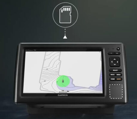
Une fois que vous avez terminé votre sortie en mer, vous pouvez enregistrer la carte bathymétrique créée sur une carte mémoire SD. Ces cartes peuvent ensuite être partagées avec d’autres utilisateurs Garmin ou chargées sur la plateforme communautaire Garmin QuickDraw Contours, où vous pourrez consulter les cartes créées par d’autres plaisanciers.
La fonction Quickdraw Contours permet de générer sa propre bathymétrie à l’aide de n’importe quelle sonde à technologie verticale, que ce soit une sonde.
DownVü
2D Chirp
NMEA2000
Panoptix Down
2D Traditionnelle
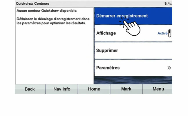
COMMENT ACTIVER QUICKDRAW CONTOURS ?
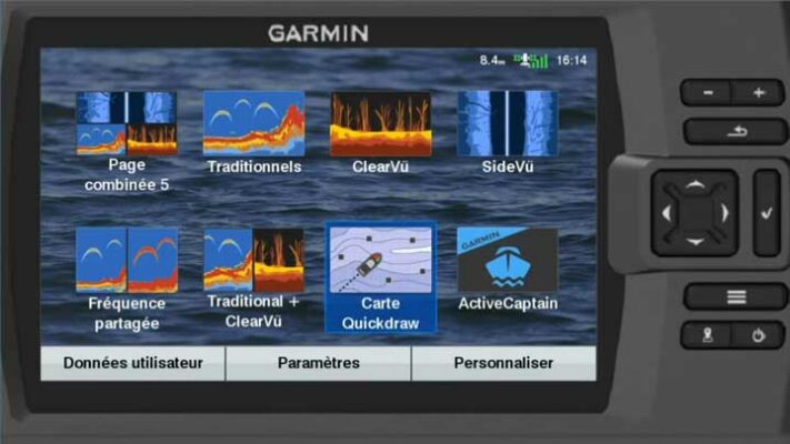
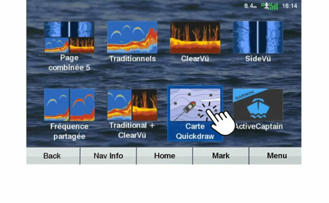
Depuis la carte de navigation, choisissez : Menu> Quickdraw Contours puis « Démarrer enregistrement ». (Les étapes et interfaces peuvent variées selon le modèle de votre GPS Sondeur)
Sélectionnez QuickDraw Contours
Cliquez sur le menu QuickDraw
Démarrez l'enregistrement QuickDraw
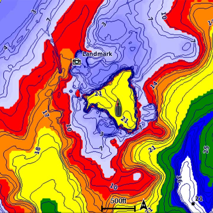
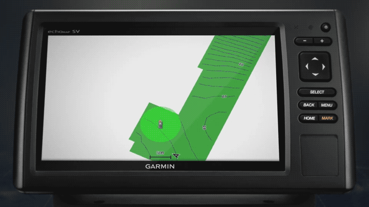
Une fois l’enregistrement activé, une carte bathymétrique avec courbes de profondeurs représentées tous les 30 cm s’affiche automatiquement. Les lignes de sondes se créent en temps réel, au fur et à mesure de votre progression sur le terrain.
Réglages quickdraw contours
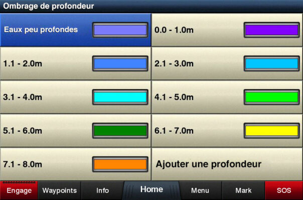
OMBRAGE DE PROFONDEUR
Il est possible d’identifier les zones d’une même profondeur grâce à la fonction « Ombrage de profondeur ». L’utilisateur peut définir la valeur mini/maxi et la couleur pour chaque zone (jusqu’à 10 zones possibles).
Paramétrage couleur ombrage de profondeur
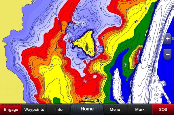
QuickDraw Contours, ombrage de profondeur
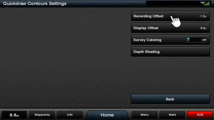
REGLAGES AVANCÉS
Quickdraw Contours permet de compenser les différences éventuelles de niveau d’eau :
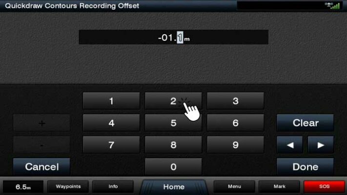
Décalage d’enregistrement : permet d’ajouter une valeur positive si le niveau d’eau du lac est plus élevé que sa hauteur habituelle le jour de l’enregistrement
Décalage d’affichage : permet de compenser les fluctuations de niveau d’eau (sur un lac de barrage par exemple) entre les données enregistrées et l’affichage des fonds le jour J.
Option décalage d'enregistrement
Compensation du décalage
COmmunauté et partage de cartes quickdraw
ENREGISTREMENT DES DONNÉES
Les données Quickdraw Contours sont automatiquement enregistrées sur l’espace mémoire disponible restant sur la carte SD.
Transférez facilement vos relevés bathymétriques sur une autre carte SD en utilisant votre ordinateur ou tout appareil compatible avec 2 ports de cartes microSD/SD. Simplifiez la gestion de vos données cartographiques et bénéficiez d’une plus grande flexibilité dans l’utilisation de vos relevés sur différents appareils.
Les traceurs Garmin récents peuvent lire une carte SDHC de 32 Go, de la classe 4 à la classe 10. Certains anciens traceurs nécessiteront une mise à jour logiciel.
La couverture complète d’une zone carrée utilise dans le meilleur cas environ 1 Mo pour 1000 acres. Une ligne droite sur une longue distance (comme de New York à Londres en pleine mer) est le pire des cas avec 1 heure à 20 mph consommant environ 40 Mo. L’utilisation moyenne serait plus proche de 1 Mo pour 100 acres.
APPLICATION MOBILE ACTIVE CAPTAIN
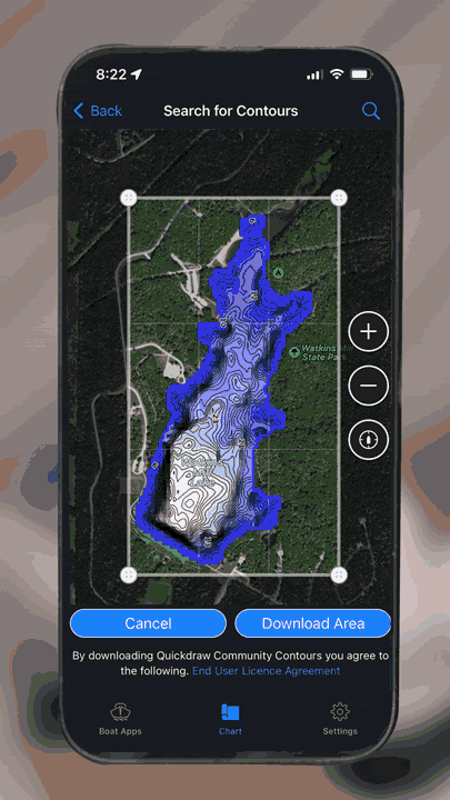
Il est possible de partager vos enregistrements Quickdraw ou de télécharger les enregistrements Quickdraw mis à disposition par d’autres utilisateurs. La communauté QuickDraw est accessible depuis un ordinateur ou depuis un Smartphone ou une tablette compatible.
L’application mobile « ActiveCaptain » est disponible sur l’AppStore ou le PlayStore.
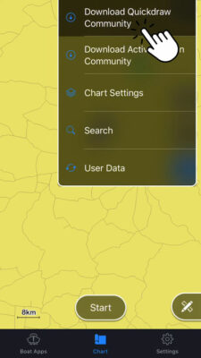
Pour télécharger des données de la communauté QuickDraw :
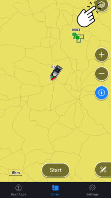
Cliquez sur le menu en haut à droite de l’écran
Cliquez sur « Télécharger depuis la Communauté Quickdraw »
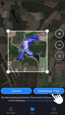
Localisez la zone que vous souhaitez télécharger
Cliquez sur « Téléchargement de la zone ».
Synchronisez ensuite les données de votre appareil mobile avec votre écran Garmin pour retrouver les données de la communauté Quickdraw sur votre combiné GPS Garmin.
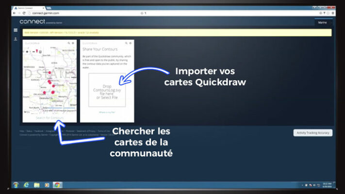
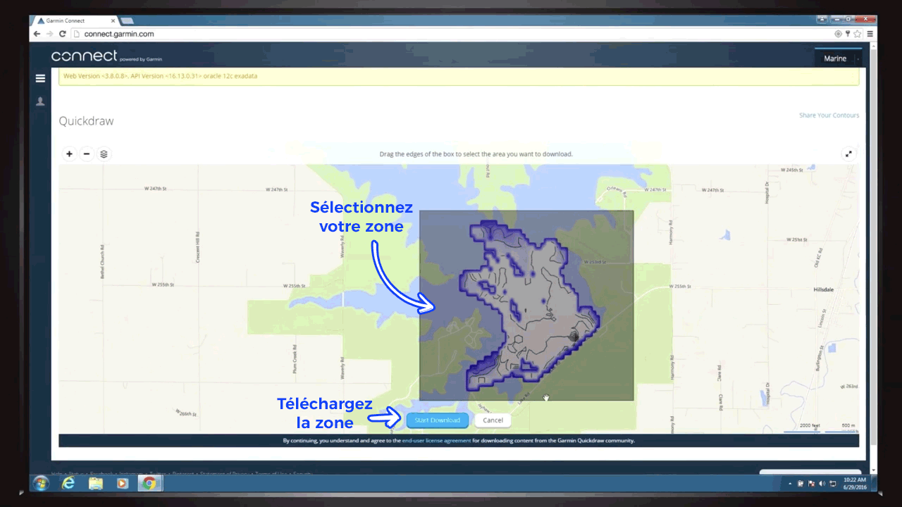
GARMIN CONNECT
Le site Garmin Connect est disponible à l’adresse suivante : connect.garmin.com. Pour vous connecter, utilisez les mêmes nom d’utilisateur et mot de passe que ceux utilisés pour l’enregistrement de votre appareil et/ou le téléchargement de la Starter Map.
Une fois sur la page d’accueil Garmin Connect, cliquez sur « Tableau de bord ». Choisissez « Marine » dans le menu déroulant, cliquez sur le bouton « + » puis ajoutez la fonction QuickDraw à votre tableau de bord. Vous accèderez à l’interface Garmin Connects QuickDraw Contours permettant de partager vos carte et d’en télécharger.
Téléchargement d'une carte quickdraw via garmin connect
Pour télécharger des cartes bathymétriques partagées par d’autres utilisateurs :
Cliquez sur « Rechercher des courbes bathymétriques »,
Localiser la zone que vous souhaitez télécharger,
Cliquez sur « Sélectionner une zone pour le téléchargement »
Cliquez sur « Démarrer le téléchargement ».
Enregistrez le fichier sur votre carte SD garmin
Enfin, insérez la carte SD contenant le fichier téléchargé dans votre appareil pour visualiser les données bathymétriques de la zone téléchargée