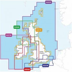
NAVIONICS - NAVIONICS+ REGULAR CARTOGRAPHY - GEOGRAPHICAL AREA UNITED KINGDOM AND IRELAND
On the water, it's essential to know your route and have maps you can rely on . Seamlessly combining marine and lake chart content, this all-in-one solution offers clear, reliable mapping for the widest range of chartplotter brands.
Navionics + maps are available on micro SD/SD memory cards for easy installation on your compatible marine device.
Choose from the different regions available in REGULAR format for the United Kingdom and Ireland in the Navionics+ range . Download the region code guide below.
|
|
|
NAVIONICS+ MAP FEATURES
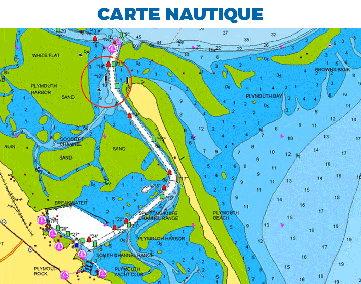
- NAUTICAL MAP: Find all the essential information you need for fishing , sailing or powerboating : harbor maps, bottom contours, navigation aids, nearby marine services and much more.
- SONARCHART BATHYMETRY HD: For improved fishing and navigation , SonarChart HD bathymetric charts display contours up to 50 cm for a more detailed representation of bottom structure.
- COMMUNITY EDITS: Benefit from the local knowledge of other boaters like yourself with this layer containing points of interest , navigation aids and various other modifications made by users of our Boating app.
- AUTOROUTING DOCK-TO-DOCK: Advanced Autorouting technology Navionics uses your boat's parameters, together with map data and frequently traveled routes , to calculate a suggested route from an actual starting point to an actual destination.
- SONARCHART LIVE: Create your own HD bathymetric charts during your outings. Watch new isobaths every 50 cm being drawn in real time as your boat moves through the water.
- CARTOGRAPHY SETTINGS: Modify the chart display Navionics to focus on the functions best suited to your needs . Highlight shallows, display areas of the same depth or identify areas with fish.
- PLOTTER SYNC: Transfer routes and marks, update your charts and much more between your chartplotter and your Navionics Boating app available on android or iOS, all via WIFI. You can even activate or renew your chartplotter subscription and download sounder logs.
|
|
HOW TO CHOOSE YOUR NAVIONICS CARD?
| NAVIONICS+ | PLATINUM+ |
|---|
| Nautical Chart |
✅ |
✅ |
| SonarChart |
✅ |
✅ |
| Community Edits |
✅ |
✅ |
| Unlimited updates |
✅ |
✅ |
| Autorouting Dock-to-dock |
✅ |
✅ |
| SonarChart Live |
✅ |
✅ |
| Cartography settings |
✅ |
✅ |
| Plotter Sync |
✅ |
✅ |
| Satellite overlay with SonarChart Shading |
❌ |
✅ |
| 3D view |
❌ |
✅ |
| Panoramic photos |
❌ |
✅ |
MAIN POINTS :
- Detailed nautical charts
- Daily updates
- Unique navigation features
- IOS and Android companion app
|
BOX CONTENTS :
- 1 - Card Navionics+ Regular (region according to model)
- 1 - micro SD to SD adapter
- 1 - PDF documentation
|