• -€16.09
  • Carte Garmin Navionics+ - Zone EUROPE CENTRALE - N°1 - comptoirnautique.com
  • Carte Garmin Navionics+ - Zone EUROPE CENTRALE EU080R - France, Lacs et Rivières / NS-EU080R - N°2 - comptoirnautique.com
  • Carte Garmin Navionics+ - Zone EUROPE CENTRALE - N°1 - comptoirnautique.com
  • Carte Garmin Navionics+ - Zone EUROPE CENTRALE EU080R - France, Lacs et Rivières / NS-EU080R - N°2 - comptoirnautique.com

Garmin Navionics + - Zone EUROPE CENTRALE card

Ref. NS-EU080R

Garmin Navionics + charts are designed for sea or inland waters , and give your chartplotter a whole new look. This all-in-one solution offers integrated mapping rich in detail , isobaths every 50 cm , and advanced functions such as automatic route creation with Auto-Guidance+ technology .

Garmin and Navionics also offer, with the purchase of a map, access to daily updates via Garmin ActiveCaptain App & Garmin Express software for 12 months (renewable after 12 months via subscription).

NB: Garmin Navionics + cards are compatible with most Garmin trackers. To be sure of compatibility, please refer to the tracker compatibility guide (download).

Read more Features
€143.90 Tax included
Public price
€159.99
-10%
Price tax excl. / DOM TOM €119.92
Geographical area
Quantity
Out of stock soon 😱
By buying this product you can collect up to 143 loyalty points. Your cart will total 143 points that can be converted into a voucher of €1.43.
NS-EU080R

Data sheet

Range
Garmin Navionics+
Geographical area
Europe
Product type
Cartography
Description

GARMIN - GARMIN NAVIONICS+ CARTOGRAPHY - GEOGRAPHICAL AREA CENTRAL EUROPE

On the water, it's essential to know your route and have maps you can rely on . Seamlessly combining marine and lake chart content, this all-in-one solution offers clear, reliable mapping for the widest range of chartplotter brands.

Garmin Navionics + maps are available on micro SD/SD memory cards for easy installation on your compatible marine device.

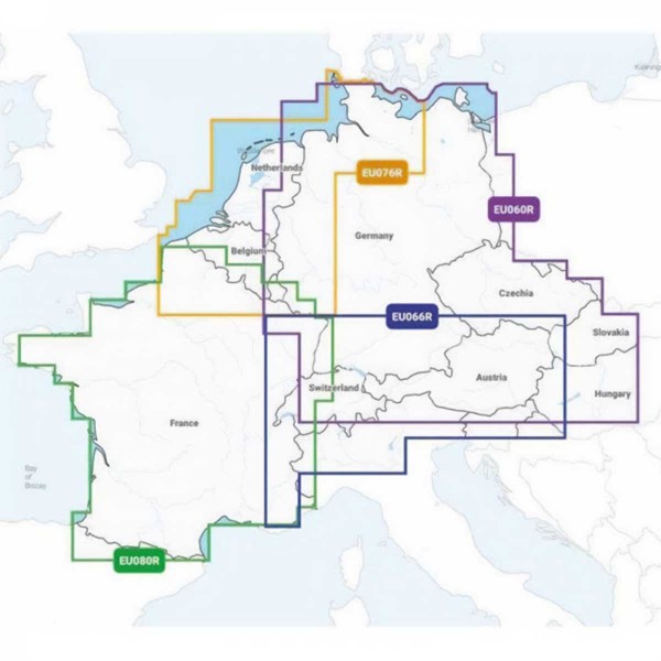
Choose from a range of regions covering Central Europe with France (lakes and rivers), Benelux and West Germany, German lakes and rivers, Alpine lakes and rivers in the Garmin Navionics + range. You can download the exact coverage of each map below.


caractéristiques des cartes garmin navionics+

GARMIN NAVIONICS+ MAP FEATURES

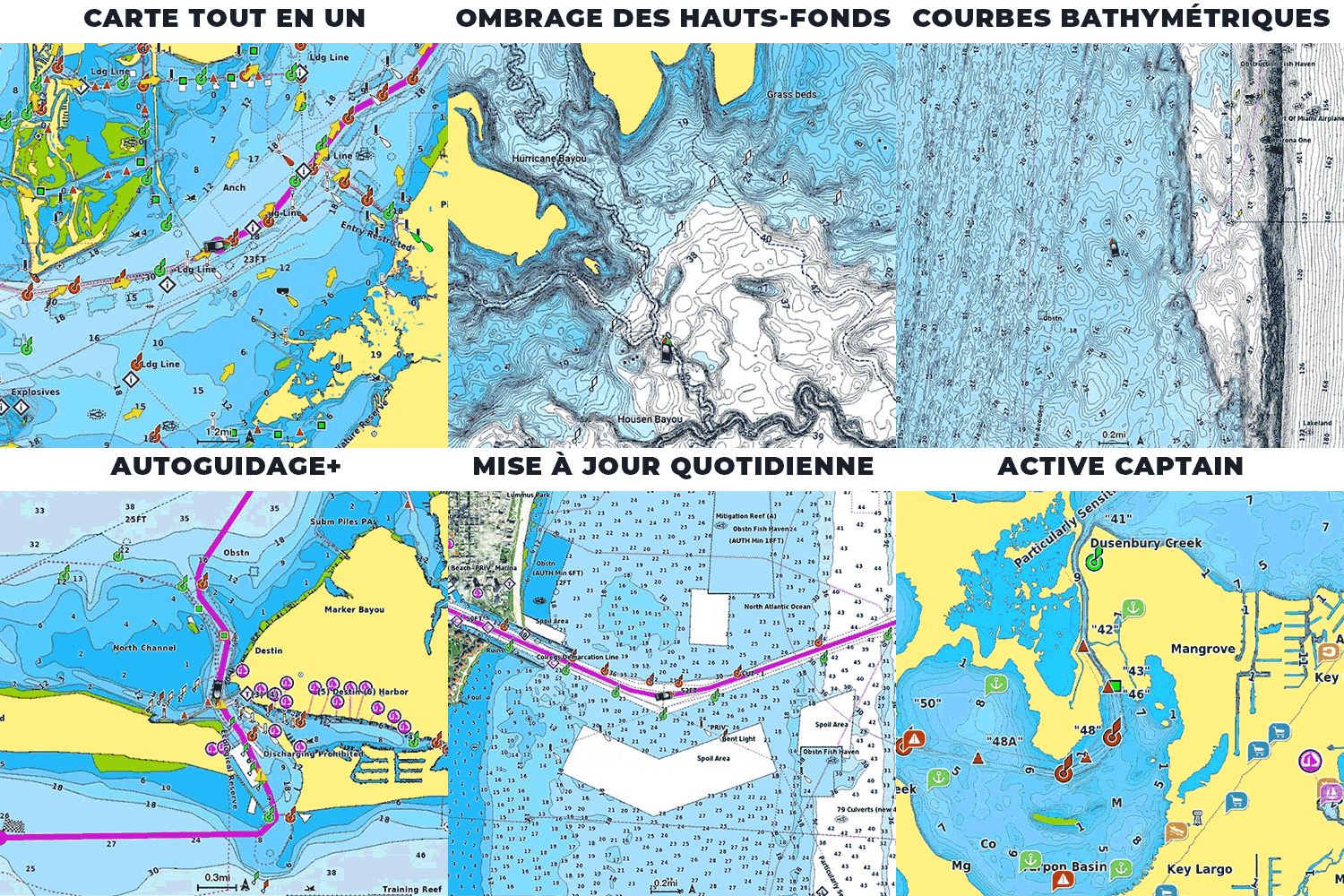
  • All-in-one mapping for chartplotters Garmin : Access detailed maps of coastal areas, lakes, rivers and more. Integrated Garmin and Navionics content provides coverage for boaters worldwide.
  • Unlimited, daily chart updates: Charts are continuously enhanced with new and updated content every day. The included one-year subscription gives you access to unlimited map updates via the ActiveCaptain app for connected devices.
  • Autoguiding+: Combines the best of the Garmin and Navionics auto-route-setting functions to give you dock-to-dock route suggestions to follow canals, waterways, marina entrances and more.
  • Depth shading: High-resolution depth zone shading lets you select up to 10 shading color options and visualize designated target depths at a glance.
  • Bathymetric curves down to 0.5 m: For improved fishing and navigation, bathymetric curves down to 0.5 m provide a clear representation of depth structure for improved fishing maps and detail in swamps, canals, harbors, marinas..
  • Shoal shading: highlights shoals to be avoided (user-configurable depth).
  • ActiveCaptain community : Community content provides useful points of interest, such as marinas, anchorages, risk areas, businesses, etc. Get recommendations from boaters with first-hand experience of the local environment.

INTRODUCTION TO THE GARMIN NAVIONICS+ MAPPING RANGE


HOW TO CHOOSE YOUR GARMIN NAVIONICS+ MAP?

GARMIN NAVIONICS+GARMIN NAVIONICS VISION+
Nautical chart
Coastal water content
Inland water content 42,000 lakes 42,000 lakes
Detailed nautical content
Bathymetric curves (up to 0.5m)
Unlimited updates ✅ (via ActiveCaptain) ✅(via ActiveCaptain)
Autoguide+ technologies
ActiveCaptain application support
ActiveCaptain community
Depth shading
Shallow shading
Relief shading ✅(via ActiveCaptain)
High-resolution satellite images ✅(via ActiveCaptain)
Aerial photography
3D Fisheye view
Marinereye 3D view

MAIN POINTS:

  • ActiveCaptain application
  • Detailed nautical charts
  • Daily updates
  • Unique navigations functionality


CONTENTS OF BOX :

  • 1 - Card Garmin Navionics + (region according to model)
  • 1 - micro SD to SD adapter
  • 1 - PDF documentation


Download

Compat. cards Garmin Navionics

Compatibility of Garmin Navionics + & Garmin Navionics Vision+ boards with plotters Garmin

Download (52.06k)

Card covers G/N zone EU Centr.

Garmin Navionics + and Vision+ Central Europe card coverage

Download (118.91k)

Customer Reviews (0)

Questions / Answers

Back to top
Cart
Your cart is empty