• -€25.09
  • Carte Garmin Navionics Vision+ - Zone EUROPE CENTRALE - N°1 - comptoirnautique.com
  • Carte Garmin Navionics Vision+ - Zone EUROPE CENTRALE EU080R - France, Lacs et Rivières / NV-EU080R - N°2 - comptoirnautique.com
  • Carte Garmin Navionics Vision+ - Zone EUROPE CENTRALE - N°1 - comptoirnautique.com
  • Carte Garmin Navionics Vision+ - Zone EUROPE CENTRALE EU080R - France, Lacs et Rivières / NV-EU080R - N°2 - comptoirnautique.com

Garmin Navionics Vision+ card - CENTRAL EUROPE zone

Ref. NV-EU080R

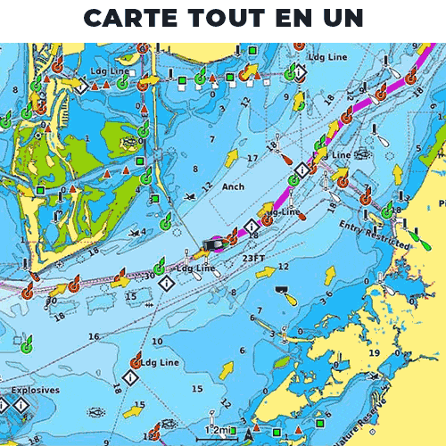
Garmin Navionics Vision+ charts are designed for sea or inland waters , and give your chartplotter a whole new look. This all-in-one solution offers integrated mapping rich in detail, isobaths every 50 cm, and advanced functions such as automatic route creation with Auto-Guidance+ technology.

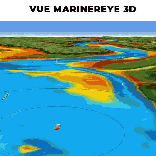
Garmin and Navionics also offer, with the purchase of a map, access to daily updates via Garmin ActiveCaptain App & Garmin Express for 12 months (renewable after 12 months via subscription) . This Vision+ version offers even more features, including HD images, Fisheye and Marinereye views and other more advanced settings.

NB: Garmin Navionics Vision+ boards are compatible with most Garmin chartplotters. To ensure compatibility, please refer to the plotter compatibility guide (download).

Read more Features
€224.90 Tax included
Public price
€249.99
-10%
Price tax excl. / DOM TOM €187.42
Geographical area
Quantity
En stock
By buying this product you can collect up to 224 loyalty points. Your cart will total 224 points that can be converted into a voucher of €2.24.
NV-EU080R

Data sheet

Range
Garmin Navionics Vision+
Geographical area
Europe
Description

GARMIN - GARMIN NAVIONICS VISION+ CARTOGRAPHY - GEOGRAPHICAL AREA CENTRAL EUROPE

On the water, it's essential to know your route and have maps you can rely on. Seamlessly combining marine and lake chart content, this all-in-one solution offers clear, reliable mapping for the widest range of chartplotter brands.

Garmin Navionics Vision+ maps are available on micro SD/SD memory cards for easy installation on your compatible marine device.

Choose from a wide range of regions including the geographical area ofCentral Europe with France (lakes and rivers), Benelux and West Germany, German lakes and rivers, Alpine lakes and rivers in the Garmin Navionics Vision+ range. You can download the exact coverage of each map below.


caractéristiques des cartes garmin navionics+

GARMIN NAVIONICS+ MAP FEATURES

  • All-in-one mapping for chartplotters Garmin : Access detailed maps of coastal areas, lakes, rivers and more. Integrated Garmin and Navionics content provides coverage for boaters worldwide.
  • Unlimited, daily chart updates: Charts are continuously enhanced with new and updated content every day. The included one-year subscription gives you access to unlimited map updates via the ActiveCaptain app for connected devices.
  • Autoguiding+: Combines the best of the Garmin and Navionics auto-route-setting functions to give you dock-to-dock route suggestions to follow canals, waterways, marina entrances and more.
  • Depth shading: High-resolution depth zone shading lets you select up to 10 shading color options and visualize designated target depths at a glance.
  • Bathymetric curves down to 0.5 m: For improved fishing and navigation, bathymetric curves down to 0.5 m provide a clear representation of depth structure for improved fishing maps and detail in swamps, canals, harbors, marinas..
  • Shoal shading: highlights shoals to be avoided (user-definable depth).
  • ActiveCaptain community: Community content provides useful points of interest, such as marinas, anchorages, risk areas, businesses, etc. Get recommendations from boaters with first-hand experience of the local environment.


GARMIN NAVIONICS VISION+ BENEFITS

  • HD Relief Shading: This high-resolution shading function combines colors and shadows to provide a clearer, easier-to-interpret view of depth structure than contour lines alone.
  • Sonar images: This downloadable feature translates the hardness of the bottom in a clear, high-contrast manner, highlighting the subtle and spectacular transition zones on some U.S. lakes.
  • HD satellite images: Downloadable high-resolution satellite images enhance vigilance.
  • Aerial photos: razor-sharp aerial and surface photos show harbors, marinas, bridges, docks, slipways, dams and navigational markers to give you a better overview of your surroundings above the water's surface.
  • Lateral analysis images: capture submerged features such as fallen timber, fish aggregators, shipwrecks, potential hazards and much more, on selected U.S. lakes.
  • 3D Fisheye view: this underwater 3D perspective view displays a three-dimensional representation of everything happening below the surface. Sonar echoes provide a personalized view.
  • Marinereye 3D view: This view provides a three-dimensional representation of the surrounding environment both above and below the boat's waterline.
  • Dynamic lake level setting: Adjust your maps to the current water level of the lake to see if certain areas are accessible or not deep enough to explore.

Caractéristiques Garmin navionics Vision+

INTRODUCTION TO THE GARMIN NAVIONICS VISION+ MAPPING RANGE


HOW TO CHOOSE YOUR GARMIN NAVIONICS VISION+ MAP?

GARMIN NAVIONICS+GARMIN NAVIONICS VISION+
Nautical chart
Coastal water content
Inland water content 42,000 lakes 42,000 lakes
Detailed nautical content
Bathymetric curves (up to 0.5m)
Unlimited updates ✅ (via ActiveCaptain) ✅(via ActiveCaptain)
Autoguide+ technologies
ActiveCaptain application support
ActiveCaptain community
Depth shading
Shallow shading
Relief shading ✅(via ActiveCaptain)
High-resolution satellite images ✅(via ActiveCaptain)
Aerial photography
3D Fisheye view
Marinereye 3D view

MAIN POINTS:

  • ActiveCaptain application
  • Detailed nautical charts
  • Daily updates
  • Unique navigations functionality


CONTENTS OF BOX :

  • 1 - Card Garmin Navionics Vision+ (region depending on model)
  • 1 - micro SD to SD adapter
  • 1 - PDF documentation


Download

Compat. cards Garmin Navionics

Compatibility of Garmin Navionics + & Garmin Navionics Vision+ boards with plotters Garmin

Download (52.06k)

Card covers G/N zone EU Centr.

Garmin Navionics + and Vision+ Central Europe card coverage

Download (118.91k)

Customer Reviews

€1,199.90 €1,579.00 -24%
  • -€379.10
Back to top
Cart
Your cart is empty