- -€14.08


C-MAP DISCOVER card - Southern Europe zone
Ref.
M-EM-Y040-MS
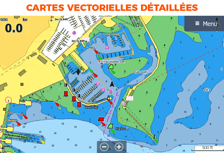
C-MAP DISCOVER and DISCOVER X charts (for NSX plotters) offer the best of high-resolution C MAP bathymetry, including Genesis data, with full vector charts, color customization (depth level), tides and currents and free Easy Routing technology without subscription.
M-EM-Y040-MS
Data sheet
- Range
- C-MAP DISCOVER, C-MAP DISCOVER X
- Geographical area
- Europe
- Product type
- Cartography
C-MAP - DISCOVER and DISCOVER X charts - Southern Europe zone
Whether for cruising, fishing or sailing, C-MAP DISCOVER and DISCOVER X charts offer the best of C-MAP. The DISCOVER range is compatible with Simrad, B&G and Lowrance chartplotters, while the DISCOVER X range is designed exclusively for Simrad NSX with the new Android-based interface.
Choose your Discover or Discover X model according to your tracker, then select the map you need from the geographical areas in Southern Europe.
Consult the compatibility table before you buy
|
|
COMMON REVEAL AND DISCOVER FEATURES
|
HOW TO CHOOSE YOUR C-MAP?
| DISCOVER | REVEAL | |
|---|---|---|
| Detailed vector map | ✅ | ✅ |
| High resolution bathymetry 2.0 | ✅ | ✅ |
| Customizable color palette | ✅ | ✅ |
| Multi-language card | ✅ | ✅ |
| Easy Routing | ✅ | ✅ |
| Tides and currents | ✅ | ✅ |
| Detailed maps of ports and marinas | ✅ | ✅ |
| Advanced lake mapping | ✅ | ✅ |
| Protected areas | ✅ | ✅ |
| Free updates - 1 year | ✅ | ✅ |
| Raster maps | ❌ | ✅ |
| Aerial photos | ❌ | ✅ |
| Satellite images | ❌ | ✅ |
| 3D background views (relief shading) | ❌ | ✅ |
MAIN POINTS:
|
CONTENTS OF THE BOX :
|
Customer Reviews (0)
No customer reviews for the moment.
Sign in to leave a review
Questions / Answers
