- -€625.00
Xplore 12 MEGA SI+
- -€149.25
The Helix 12 G4N MEGA DI+ from Humminbird features a 12" panoramic color display with LED backlighting. It's a GPS chartplotter/fishfinder handset equipped with the new Dual Spectrum transducer. With the MEGA Down Imaging+ version, it's the ultimate tool for fishermen.
Read more FeaturesData sheet
Like all Humminbird devices, it is extremely intuitive to use. This new generation of fishfinders features a side-mounted keypad for easy operation. It can be operated with the default settings, but can also be parameterized to enhance your unit's performance using the shortcut keys.
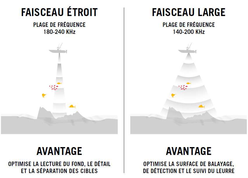
The Helix 12's integrated dual-frequency sounder, equipped with a 20° and 60° dual-beam transducer, provides both excellent bottom relief accuracy and fish detection over a total coverage of 60° for an optimum range of 200m.
The HELIX G4N series integrates NMEA 2000 support to display engine and boat information, as well as navigation weather data.
|
|
TRADITIONAL 2D CHIRP SOUNDERThe traditional sounder function uses high-frequency CHIRP coverage on a wider beam than usual, enabling optimum detection down to 100m depth without any problems. With CHIRP technology, you benefit from:
|
|
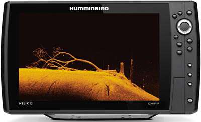
MEGA DOWN IMAGING+ TECHNOLOGYThe new MEGA Imaging+ function takes Down imaging performance to a new level, doubling the depth of use of Mega Down imaging. You can now explore depths at very high frequencies that were previously inaccessible... while retaining stunning image quality. |
 |
|
 |
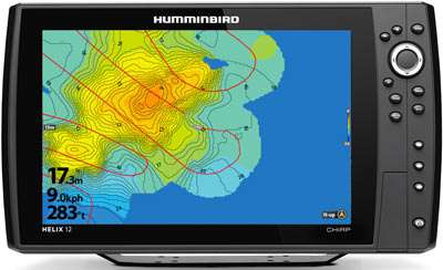
AUTOCHART LIVEThe AutoChart Live function enables users to map and create bathymetry of any body of water for their own private use. The AutoChart Live software is pre-loaded with 8 hours of memory to enable detailed bathymetric mapping of the seabed. This feature now includes the ability to display variations in vegetation and bottom hardness. Maps are created live on-screen as you prospect. To increase the memory capacity of the AutoChart Live function, the AutoChart card is required. |
|
GPSThe Humminbird Helix 12 is equipped with a state-of-the-art WAAS GPS antenna for high accuracy. This means you'll be able to pinpoint your position with the utmost precision, so you can get the job done. Reliable navigation - Easy to use - Highly accurate built-in GPS antenna and detailed mapping. Micro SD card that can be used to display Navionics+ and SYLMAPS maps. Please note that the Navigation map is not supplied as standard. |
|
|
 |
DUAL SPECTRUM PROBEThis wide-beam, multi-frequency probe has a scanning range of 140 to 240khz. It incorporates the best ceramics available. With a very low "Q" factor to protect the ceramics from unnecessary vibration, it delivers the clearest, most accurate image of the water layer. The narrow beam operating at 180-240khz allows you to optimize bottom detail and readability. You can also combine the two beams to make the most of both frequency ranges. This new DUAL SPECTRUM technology now equips all Humminbird Helix G4N handsets, including DS, MDI & MSI models. |
|
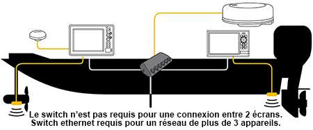
INTERCONNECT YOUR DEVICESThe ethernet network lets you interconnect Humminbird devices with the greatest of ease. Devices equipped with this feature can exchange data from the various sensors connected to the network (depth sounder, GPS antenna, radar...). All data is available on the screens, except for shared cartography. For 3 or more devices or accessories, an ethernet switch is required. |
 |
|
MAIN POINTS :
|
BOX CONTENTS :
|
FREQUENCIES :
|
Accessories
Customer Reviews (0)
Questions / Answers